Complete collection of cards can be found in this web photo album. I will also post some of them at the end of this post.
| ||
| New Cumberland West Virginia |
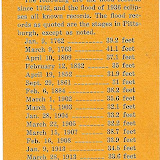
On March 18 and 19, 1936 the town of New Cumberland and Hancock County, (and the surrounding Ohio River area) experienced the worst flood in its history when the river peaked at Dam No. 9 in New Cumberland at 51.6 feet, about 26 feet above flood stage. New Cumberland is 54.4 river miles below Pittsburgh, or 44.1 miles NW via US-22 and and WV-2 highways.
Known as the "Great St. Patrick's Day Flood," according to Wikipedia this was also the worst flood in the history of Pittsburgh where flood levels peaked at 46 feet. Railroad service, communication and utilities were out of commission for up to two weeks, while the damage to steel mills caused hardship to over 60,000 workers within a 30-mile radius.
In addition to a wet March, flooding was a result of warmer than normal temperatures causing the melting of snow and ice on the upper Allegheny and Monongahela rivers.
Not much is available online specifically about Hancock County flooding, although did find a publication called 1936 WWVA Wheeling WV Flood Souvenir Book, listed as being in the archives at the West Virginia University Library but not available for loan. WWVA is a radio station in Wheeling, first licensed in 1926. Their 10th Anniversary in 1936 was a year of several weather related disasters. High winds of 100mph+ hit the area in July 1936.
From History of WWVA, Wheeling
At 9 am on Tuesday, March 17, 1936, WWVA received first word of warning from the Wheeling Chamber of Commerce that high water was on its way to Wheeling. Two days later, at 3 pm on Thursday, March 19th, an angry avalanche of watery destruction roared down the Ohio River.
Through the dark and anguishing hours, WWVA staff, entertainers and engineers responded unselfishly and untiringly, maintaining 92.5 hours of continuous broadcasting, sending out bulletins, flood reports and spirit-lifting musical entertainment to residents of the stricken area. All other forms of communication had been destroyed by the swift and destructive waters of the Ohio River.
An Ohio River flood in late January 1937 was not as severe in New Cumberland (only 18 feet above flood stage as opposed to 26 feet in '36) but had far greater impact down river in southern Ohio, Indiana and norther Kentucky. In Cincinnati, the Ohio River crested at 80 feet, 28 feet over flood stage and 9 feet above the previous 1884 record.
The floods of 1936 and 1937 were so unprecedented that civic and industrial groups forced authorities to create a comprehensive plan for flood control, which the Army Corps of Engineers completed in the early 1940s. The history of the Corps began with the building of fortifications during the Revolutionary War. Their authority over river works in the US began with the fortification of New Orleans after the War of 1812.
Construction on Dam No. 9 in New Cumberland began in 1910 after the completion of Dam No. 8 in East Liverpool and was completed c1912. The National Construction Co. of Evansville, Indiana was awarded the contract after a bid of $912,456. The Cincinnati Library has an online collection of pictures of dams and locks including the newer one in New Cumberland. Here are the links for those specific to New Cumberland: 2007 Locks and Dam Building, 1959 view of lock at Stratton OH [across the river from NC].
The current New Cumberland Locks and Dam is located two miles north of New Cumberland and was constructed from 1955 to 1961, replacing Dams 7, 8 and 9 which were constructed 1904-1914. Dam No. 9 was at New Cumberland and contained a single lock and an old-style wooden wicket dam.


Flood Scene - New Cumberland, W.Va, March 19, 1936. This is a view of Rev. Fr. Okzewski residence, upset. Located in upper town, south of Peoples Store building. The Polish Priest lost another house and it landed in the Dr. Beaumont lot in lower town.

Harry Sprague's garage, upper town, moved its location from the David Ward property and landed on Railroad near residence of Ira Donovan.

The Dominick DeRiso Shop and dwelling on Chestnut Street, below the Railroad Station, showing wreckage that lodged against the DeRiso property. The water was on the second floor of the dwellings.

Bank corner – water coming up – Auto caught in flood tide. Small building opposite is 'Squire Milligan's office, before it left its mooring.

A view of Eden Valley. The Forrest house occupied by Frank Carpenter, the next is the John Reed dwelling and the Phil White house, occupied by B.F. Harper and family.

This view shows the Penna. Railroad Station after it collapsed. The white scene is the heavy snow that fell Saturday, March 21, the first day of spring.

Ireal "Tony" Glover's house floated with the swift current, it was caught down at Black Horse. The dwelling was located on the west side of the road opposite the Chelsea row of houses.


No comments:
Post a Comment